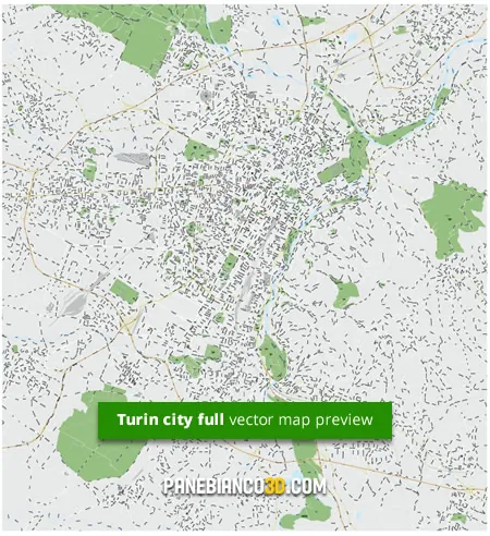
Vector map of Turin - full city (Torino, Piedmont, Italy)
Map of Turin (full city) in vectors, made with Adobe Illustrator CS for professional purposes: any company, agency or freelancer can buy a license and use this map to accelerate their work.
Please Note:
Turin city vector map is available in this website in 2 different areas:
- Turin City Centre: a smaller area, with the city centre only with main turistic places
- Turin full city (with some suburbs): the whole Turin area, comprehensive of parts of peripheral areas
The map is divided into different layers, each for different types of objects: for example, a layer for the waters (sea, rivers, lakes, ponds),
one for green areas (gardens, forests), one for street lines, a different layer for labels (names of streets, subway stations (M),
bus stations, etc.), a layer for icons.
Vector map of Turin full city: technical description
This map has been completely drawn in vectors, based on Google Maps data. Its main features are:
- Vector map created with Adobe Illustrator CS4.
- Multilevel vector map: each layer will include the objects of a particular type; for example, a layer will include all the gardens, one will contain the rivers, one of the addresses, points of interest, etc.
- you can customize the map, changing the colors of objects, color and / or thickness of the edges in a few clicks, doing massive operations in a very easy way.
- All texts (street names, subway stations, bus stops, points of interest, etc.) will be selected and editable:
- you can change the font type, size, color, of all texts;
- The map is provided with all the texts in Arial, for better compatibility with all systems.
- To ensure the area covered by this map is "ok" for your needs, please check this preview version of the map of Turin (full city map) in JPG format linked below:

End user license for multiple projects but for a single user
These maps are sold with a single user license:
- The license is valid for one user only (individual company)
- The user who purchases the license may use it for their projects, but can not transfer the license to other companies if a project has been already complete.
- For example, if you are an agency or a freelance, you can get a license to build one or more jobs for yourself OR for your client. In this case the license will be transferred to your client and you can't use it for your internal / personal projects.
- If you need to develop other projects for different clients, you will need to purchase a new license.
- For more information, please refers to the "Licenses" page


